Sunday, November 29, 2009

Izadkhast Fortress

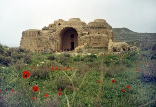
The Fortress of Izadkhast (قلعه ایزدخواست) is located in the Fars Province of Iran, roughly 135 km south of Isfahan. This historical complex has been situated on a natural base along with unique characteristics. The complex contains the castle of Izadkhast, one caravanserai and the Safavid-period bridge. The works inside of the castle belong to different periods from Sassanids to Qajars. The most important section of the complex is the castle that has been built on singular bedrock in a sand construction and close to the valley of Izadkhast. A bridge and a gate in the most accessible part of the complex made it possible to connect with the surrounding areas. 

It is, in form of construction, unique but can be, from the-materials-used point of view, compared with Citadel of Bam, Rhine and many other citadels, castles built in provinces of Yazd and Kerman. The complex caravanserai can be compared with Safavid caravanserais especially the caravanserais in Isfahan-Shiraz Route.  


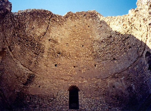
Inside the walls of the fortress, there are alleyways and passages that criss-cross it. Right by the front gate that goes over a moat, there are many homes that are now fully deserted while some are completely destroyed. According to the locals, as recent as the turn of the millennium, people still lived in the old part of Izadkhast but due to floods in the past two years, the homes were destroyed and people were forced to move. Most of the homes in the interior were constructed from wood and mud. The smallness of the bedrock led to agglomeration of built rooms. Hence, the smallness of rooms resulted in increase of floors, some as many as five stories high which in itself and considering the circumstances of its time is a remarkable architectural feat. 

The caravanserai at the castle dates back to the time of Safavid Dynasty (1502 - 1736). The front gate was burned down by Nader Shah's soldiers camping there during a cold night as they were looking for firewood.  


The bedrock on which the complex is situated on protected the castle from the foreigners' attacks. The tall and almost perpendicular height, ranging from 6 to 15 meters, on three sides of the fortress made it almost impossible for enemies to gain access to the interior. And for further protection, on the fourth and shorter side, a moat 30 meters long, 4 meters across and 4 meters deep had been dug. 
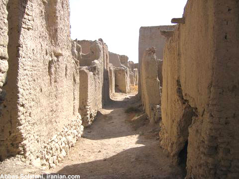
Many parts of the Izadkhast fortress have been destroyed as they have collapsed due to erosion and flooding. Inside the walled city, there are clear signs of damage from treasure hunters and unfortunately also graffiti on the walls. 


Band'e Amir


The Amir Dam (بند امیر) is an example of the magnificent water engineering works achieved by the old Persian engineers and the only remaining dam from the Buyid dynasty. It is fully functional and provides a small reservoir habitat for fishes. It is located 40 kilometers north east of Shiraz and 15 kilometers south of Marvdasht, situated across the Kor River and adjacent to the Band’e Amir village. Assumed to have been built in the 10th century, it is considered one of the architectural masterpieces of its time. In addition to its solid structure that has stood the test of time, it continues to successfully regulate the flow of the river, a nod to the precise work done in its construction centuries ago.  


During the Buyid dynasty, along the Kor River a system of 6 dams were constructed with the Amir Dam being the most important of them. The water passing through these dams was mainly used to irrigate surrounding fields and operate water mills. Some historical documents indicate that the Amir dam was built by the orders of Amir Azdoddoleh Deylami, hence giving it its name.  


The structure of the dam consists of two sections; the dam portion and the bridge portion. The main elements used in its construction are rocks connected by metal joints. The dam stretches 120 meters across and was the first connection in the region between the opposite sides of the river.  


In the west side of the dam there is a deep rectangular shape opening measuring 10 meters across and 7 meters deep which was used as a way to redirect the flow of water when necessary. When open, the entire flow of the river would be able to be redirected through this canal. Locally known as the Gav-Shir canal, it stretches 40 meters before making a 90 degree turn to the left and continuing for another 800 meters before rejoining the main river again. In recent years 2 hatches have been added to control access to the canal. Due to its strategic location, water can gather for quite a distance behind the dam and measuring 7 meters deep. As a result a total of 24 villages around the Kor River can gain access to and take advantage of the blocked body of water.


Friday, November 27, 2009

Goor Dokhtar

Goor Dokhtar (گور دختر) is a structure very similar to the mausoleum of Cyrus the Great. This structure is made of 24 slabs of stones, according to the Orartoie and Elamite principles such as the ziggurat of Choghazanbil. It is believed that Goor Dokhtar dates back to the Achaemenid era and is thought to be the resting place of the daughter or sister of Cyrus the Great, although the more prominent belief is that it may be that of his grandfather. While modern maps of the area place Goor Dokhtar in the Bushehr province, due to the proximity to Kazeroon, many tourist brochures of Kazeroon will claim Goor Dokhtar as their own. Goor Dokhtar literally means Zoroastrian girl. 


While from a historical standpoint Goor Dokhtar is not any less important than Pasargadae, however, it currently sits alone and unattended in Dasht Eram in Bushehr, surrounded by mountains on all four sides. Without even knowing the history behind it simply its physical characteristics and appearance remind one of Pasargadae and any possible connection between the two structures. 


Goor Dokhtar is a rectangular structure with a pointed roof which sits on top of a platform with 3 steps. The platform measures 5.5 by 4.5 meters and one meter high while the monument itself is 3 by 2 meters and with a height of 5.1 meters. Its entrance faces northwest and had a stone door which has long since disappeared and today simply appears as an opening. Currently the inside of the monument is empty and there is reason to believe that an inscription used to exist on the V shaped gable ceiling.  


On the exterior of the roof, the stone which formed one side of the arched roof has been removed by vandals and its broken pieces are scattered around the structure. While from a preservation point this act is very unfortunate, however, it led to the discovery of an open space under the roof. Unlike Pasargadae this space had no opening to the outside and thus makes it unlikely that it was to contain a corpse.  


Goor Dokhtar was discovered in 1960 by the Belgian archeologist Louis Vandenberg. This valuable monument is registered on the records of the Cultural Heritage Organization of Iran. 


Castle of Ardeshir

Castle of Ardeshir’e Babakan (قلعه اردشیر), also known as the Atash-kadeh, is a castle located on the slopes of the mountain on which Ghaleh Dokhtar is situated on. Built in AD 224 by Ardashir I of the Sassanian Empire, it is located two kilometres (1.2 miles) north of the ancient city of Gor, i.e. the old city of Firouzabad in Fars.  

The structure contains three domes, among other features, making it a bit larger and more magnificent than its predecessor the nearby castle of Ghaleh Dokhtar. However, it seems that the compound was designed to display the royalty image of Ardashir I, rather than being a fortified structure for defense purposes. That is why perhaps it would be best to refer to the structure as a "palace" rather than a "castle", even though it has huge walls on the perimeters (twice as thick as Ghaleh Dokhtar), and is a contained structure. From the architectural design, it seems the palace was more of a place of social gathering where guests would be introduced to the imperial throne.  

What is particularly interesting about this palace is that its architectural design does not exactly fall into that of the Parthians or even Sassanian category; the design is a unique design particular to architects of Fars. 

The palace was built next to a picturesque pond (on the bank of the western branch of Tangab River) that was fed by a natural spring, perhaps in connection with the Persian goddess of water and growth, Anahita. . The spring is thought to have fed a royal garden, in the same way that Cyrus had his garden built at Pasargadae. The pond was tiled on its sides, surrounded by pavement for guests of the royal court to enjoy the evenings by. 

The structure is 104m by 55m. The balcony is 18m high, although it has partially collapsed. The walls were built of rubble with quick-setting mortar and were as much as 4 metres wide. The outer walls seem to have been slightly articulated by two rows of vertical niches. This articulation, however, would not have detracted from the massive defensible appearance of the structure, to which the low heavy cupolas must have contributed. Originally the rubble walls were covered with stucco, which is still preserved in some places in the domed halls and in the court of the palace. Niches, with a semi-circular top, were set in rectangular frames and moulded in the stucco. The lintel of these niches was formed by a cavetto cornice of the type used on the lintels of windows and doors in the palaces of Persepolis from which those of Firuzabad were surely copied in a conscious imitation of Achaemenid architectural features. The balcony, as in the Parthian palace of Ashur, was designed with the ancient Near Eastern type of house in which the rooms open on an inner court to produce a complex which was well suited to the climate of these regions. The style of the interior design is comparable to that of Tachar palace at Persepolis.  

Direct parallels have been discovered between the Castle of Ardeshir and the Basilica of Maxentius in Rome. 


Wednesday, November 25, 2009

Qara Church


The St. Thaddeus Church best known as Qara Church (کلیسای قره) and Tatavoos Church (which literally means Black church) is an ancient Armenian monastery perched on a mountain ridge in the northern Iranian province of West Azerbaijan. Located 20 kilometers south of Maku, the massive church can be seen against the natural background of rolling hills; its cuspidate tambours catches the eye of beauty-seekers. As one of the oldest and most notable surviving Christian monuments of Iran, Qara Church carries great significance for the country's Armenian Orthodox community. Armenians hold that Qara Kelisa is the world's first church and was constructed in 68 CE by one of the apostles of Jesus, Saint Thaddeus, who traveled to Armenia, then part of the Persian Empire, to preach the teachings of Christ.

According to historical records of the Sassanid period, some of the Armenians were the followers of prophet Zoroaster, whereas some were sun worshipers. In the year 43 AD. two men by the names of Tatavoos and Batholemus preached on Christianity in the vicinity of Azerbaijan, thereby gaining a number of followers estimated at 3,500 people, including the daughter of the monarch of the time. In order to stop the advancement of Christianity, the Armenian ruler ordered for their massacre in the year 66 AD. It is said that their bodies were buried in the vicinity of this church. 

Much of the existing structure dates back to the 19th century when the Qajar prince Abbas Mirza renovated the monument using carved sandstone. An ancient chapel two kilometers northwest of Qara Church is said to have been the place where the first Christian woman, Sandokh, was martyred. The chapel is believed to be as old as the Black Church. Apart from the Armenian architectural elements visible in the structure of Qara Church, another remarkable feature of the historical church is its spatial layout, which resembles that of the Echmiazin Cathedral in Armenia. 


The church is composed of two parts: a black structure, the original building of the church and a white structure, the main church, which was added to the original building's western wing in 1810 CE. The original church is a domed sanctuary built largely of dark-colored stone, probably dating to the tenth or eleventh century, from which its name Qara Church is derived. The main church, built in 1811-1820 is a massive structure, built of light sandstone and adorned with blind arches and decorative and geometric shapes. The cruciform building is surmounted by two pyramidal shaped cupolas, the shorter of which has light and dark colored horizontal bands on the drum. Its twelve-sided tambour has been built in alternating light- and dark-colored stones and has an equal number of windows. 


The church has two large courtyards, the first of which seems to have been used for agricultural purposes, while the second encircles the white structure, the portico, and a number of rooms. The first courtyard includes oil-extracting rooms, a miniature windmill, an oven, and a fountain. It is decorated with ornamental motifs and two intricately designed stone crucifixes. A small door opens to the second courtyard where the refectory and the kitchen along with rooms for resident monks and abbots are located. The portico, which has been left unfinished, dates back to the mid 19th century. 


The building's exterior is adorned with five rows of alternating dark and light stones as well as numerous round and blind arches, decorated with rosettes, coats-of-arms, flowers and animal figures. Statues of angels adorn the front facade of the church and its northern and southern facades are decorated with dark-colored stone crucifixes. Sculptured bas-reliefs bearing passages from the Old and New Testaments, mythical animals and effigies of saints have added to the beauty of the monument. In the eastern part of the complex, there is a chapel and a sacristy hall. An Armenian inscription, carved on stone, gives an account of the construction of the buildings. Another stone inscription can be seen on the front of the old portal, bearing the date when the monument was reconstructed by Abbas Mirza Qajar.  


Not much appears to remain of the original church, which was extensively rebuilt in 1329 after an earthquake destroyed the structure in 1319. Nevertheless, some of the parts surrounding the altar date from the 10th century. Throughout the course of history Qara Church sustained damage and was repaired a number of times. A large part of the monument was destroyed during the Mongol invasion in the 13th century. The Persian scientist Khajeh Nasireddin Tusi oversaw its reconstruction during the reign of the Mongol ruler, Hulagu Khan. 


Every year scores of Armenians, Assyrians and Catholics from Iran and other countries visit the church to commemorate the martyrdom of Saint Thaddeus and his faithful followers and to perform religious rituals.  


Qara Kelisa has been registered as the ninth Iranian historical-cultural heritage site on the United Nations Educational Scientific and Cultural Organization's (UNESCO) World Heritage List.